Useful Links
New Zealand has become adept at marketing itself as a tourism destination, and a quick search of the internet will reveal a plethora of information for intending visitors.A great place to start looking is the Tourism New Zealand web site, while the cycle tourist will find much useful information on the CycleTour New Zealand website.
An excellent guide book is Nigel Rushton's "Pedallers' Paradise", as is the Kennett brothers Classic New Zealand Cycle Trails. The WikiCamps NZ app has a comprehensive listing of camp grounds and accommodation. If you are planning to venture onto the back roads, detailed maps can be viewed online at NZ Topo Maps. More maps can be downloaded from PDF Maps. A handy Christchurch cycle routes map is available here .
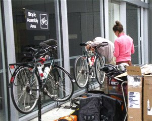
Tourists arriving at Christchurch Airport will find excellent bicycle assembly facilities await them.
Bike cases can be stored by and recycled bike boxes purchased from Luggage Solutions. Mobile phones and SIM cards can be purchased or rented at the Vodafone Rentals Kiosk
If you prefer a transfer from the airport to your accommodation the Super Shuttle service uses mini-buses with baggage trailers and is very economical.
Bookings for the TranzAlpine Scenic Train and other train services can be made on the Kiwi Rail web site.
The Route
Starting in Christchurch I'll make a loop around the top of the island. The ultimate direction of travel will depend upon the way the wind is blowing upon departure, but the initial plan is to head west to Arthur's Pass, a crossing I had planned to do on my first tour but had abandoned when the weather was unfavourable.
After crossing the pass I'll head north past the pancake rocks of Punakaiki to Westport, then follow the Buller Gorge to Muchison, before heading to Motueka via Glenhope. From there I'll cross the notorious Takaka Hill on the way the fabled Golden Bay, where I hope to take a kayak tour in the Abel Tasman National Park.
From Golden Bay I'll return through Motueka to Nelson before heading south to St Arnaud, where I'll take to the backroads, crossing the Rainbow Road through the Upper Wairau Valley to Hanmer Springs, then on to the Archeron Road through Molesworth Station to Seddon.
It will be all downhill from here as I make my way south along the coast to Kaikoura, then on to the Inland Kaikoura Road through Mt Lyford and Waikari back to Christchurch.
View Larger Map
Itinerary
This is the plan, but as always I'm prepared to be flexible if necessary. There is a one-day buffer at the end in case of any delays - if not used I'll spend it sightseeing around the Christchurch area.The detailed itinerary is here: NZ 2015 Itinerary.
No comments:
Post a Comment