In October 2010 I made my first cycle tour of New Zealand. I arrived in Christchurch shortly after a severe earthquake, and was shocked to see the damage wreaked upon this charming provincial city. So I vowed to return and try to make some contribution, however small, to the economic recovery of the region.
Little did I to know that far worse was to come - a second major quake devastated large sections of the city, many homes and many of the historic buildings that gave the city its charm and character were destroyed, including the iconic Christchurch Cathedral, and sadly, many lives were lost.
My first attempt at a return visit in 2011 was thwarted by a volcanic eruption in Chile - the ash cloud from the eruption circled the globe, and my flight to New Zealand was cancelled at the last moment.
In 2012 I returned to New Zealand to tour the Southland, but my route did not visit Christchurch. Now, a further two years later, I'm preparing once again to tour.
This visit I'm going to complete my explorations of the South Island, starting with a crossing of Arthur's Pass to the wild and wet west coast. And once again I'll be taking to some of the region's back roads.
So, return flights to Christchurch are booked, leave is approved, and a new expedition touring bike awaits. I'm ready to roll...
Maps and Information: Which way to go...
Useful Links
New Zealand has become adept at marketing itself as a tourism destination, and a quick search of the internet will reveal a plethora of information for intending visitors.A great place to start looking is the Tourism New Zealand web site, while the cycle tourist will find much useful information on the CycleTour New Zealand website.
An excellent guide book is Nigel Rushton's "Pedallers' Paradise", as is the Kennett brothers Classic New Zealand Cycle Trails. The WikiCamps NZ app has a comprehensive listing of camp grounds and accommodation. If you are planning to venture onto the back roads, detailed maps can be viewed online at NZ Topo Maps. More maps can be downloaded from PDF Maps. A handy Christchurch cycle routes map is available here .
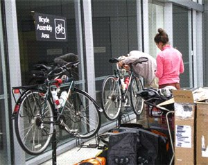
Tourists arriving at Christchurch Airport will find excellent bicycle assembly facilities await them.
Bike cases can be stored by and recycled bike boxes purchased from Luggage Solutions. Mobile phones and SIM cards can be purchased or rented at the Vodafone Rentals Kiosk
If you prefer a transfer from the airport to your accommodation the Super Shuttle service uses mini-buses with baggage trailers and is very economical.
Bookings for the TranzAlpine Scenic Train and other train services can be made on the Kiwi Rail web site.
The Route
Starting in Christchurch I'll make a loop around the top of the island. The ultimate direction of travel will depend upon the way the wind is blowing upon departure, but the initial plan is to head west to Arthur's Pass, a crossing I had planned to do on my first tour but had abandoned when the weather was unfavourable.
After crossing the pass I'll head north past the pancake rocks of Punakaiki to Westport, then follow the Buller Gorge to Muchison, before heading to Motueka via Glenhope. From there I'll cross the notorious Takaka Hill on the way the fabled Golden Bay, where I hope to take a kayak tour in the Abel Tasman National Park.
From Golden Bay I'll return through Motueka to Nelson before heading south to St Arnaud, where I'll take to the backroads, crossing the Rainbow Road through the Upper Wairau Valley to Hanmer Springs, then on to the Archeron Road through Molesworth Station to Seddon.
It will be all downhill from here as I make my way south along the coast to Kaikoura, then on to the Inland Kaikoura Road through Mt Lyford and Waikari back to Christchurch.
View Larger Map
Itinerary
This is the plan, but as always I'm prepared to be flexible if necessary. There is a one-day buffer at the end in case of any delays - if not used I'll spend it sightseeing around the Christchurch area.The detailed itinerary is here: NZ 2015 Itinerary.
New Zealand Climate: Wet and wetter...
Eastern South Island
The climate of this zone is greatly dependent on the lie of the massive Southern Alps to the west. Summer temperatures are warm, with highest temperatures occurring when hot dry foehn northwesterlies blow over the Alps and plains. Mean annual rainfall is low, and long dry spells can occur, especially in summer. For much of the time summer temperatures are moderated by a cool northeasterly sea breeze.Typical summer daytime maximum air temperatures range from 18°C to 26°C, but may rise to more than 30°C. A temperature of 42°C has been recorded in Christchurch. Winters are cold with frequent frost. Typical winter daytime maximum air temperatures range from 7°C to 14°C. Northeasterlies prevail about the coast for much of the year. Southwesterlies are more frequent during winter.

Western South Island
The climate of this area is greatly dependent on its exposure to weather systems from the Tasman Sea and the lie of the Southern Alps to the east. Although mean annual rainfall is very high, dry spells do occur, especially in late summer and during winter. Heavy rainfall occurs from the northwest. Summers are mild.Typical summer daytime maximum air temperatures range from 17°C to 22°C and seldom exceed 25°C. Winter days often start with frost. Typical winter daytime maximum air temperatures range from 10°C to 14°C. Northnortheast winds prevail along the coast in Westport and Hokitika while southwesterlies prevail in coastal areas further south. Sea breezes can occur on warm summer days.

The bike and baggage: Ready for an expedition...
I have different bike for this tour. It's a Van Nicholas Pioneer: a Rohloff-equipped titanium-framed expedition touring bike. If you are interested in the details, you can read about the building the bike in a series of posts on my whispering wheels web page.

Once again, my equipment is almost entirely lightweight gear - stuff which I have used extensively for bushwalking in Australia and trekking in Nepal, and on my previous cycling tours. My philosophy is to carry no more weight on my bike than I would on my back, that is, less than 20 kg, and preferably, no more than 15 kg.
Here are my gear selections and checklist. Touring Gear Checklist
Where am I? - tracking my location...
Once again on this tour I'm planning to explore some NZ backroads - places where cycle tourists don't usually venture, and where there is likely to be little traffic of any kind. So as a solo traveller it seems a sensible precaution to have a means of requesting assistance in the event of a mishap.
I started by investigating personal locator beacons - but soon found that PLB's are only capable of one-way communications, and are relatively expensive for devices with limited capabilities. So I investigated several tracking devices, and eventually settled on the DeLorme Inreach.
The Inreach is a little cheaper than a PLB, but of course there is a catch - you must sign up to a service plan with the Iridium satellite service. It's still expensive but the SOS service provides affordable peace of mind. Best of all it allows two-way messaging and tracking. And the Inreach synchronises with an iOS or Android smartphone to send and receive messages and to provide full GPS navigation using the DeLorme Earthmate app.
So my little free-loading friend Boofle will be coming along to help with the navigation, and you will be able find out where we are by clicking the link on the sidebar.
The link will take you to the DeLorme Mapshare page. You will need the Internet Explorer or Firefox browser to view the map.
I started by investigating personal locator beacons - but soon found that PLB's are only capable of one-way communications, and are relatively expensive for devices with limited capabilities. So I investigated several tracking devices, and eventually settled on the DeLorme Inreach.
The Inreach is a little cheaper than a PLB, but of course there is a catch - you must sign up to a service plan with the Iridium satellite service. It's still expensive but the SOS service provides affordable peace of mind. Best of all it allows two-way messaging and tracking. And the Inreach synchronises with an iOS or Android smartphone to send and receive messages and to provide full GPS navigation using the DeLorme Earthmate app.
So my little free-loading friend Boofle will be coming along to help with the navigation, and you will be able find out where we are by clicking the link on the sidebar.
 |
| Where's Boofle |
Christchurch: rising from the rubble
After a smooth and uneventful flight yesterday we touched down at Christchurch Airport. I'd hoped to grab a shot of the Southern Alps as we crossed, but unfortunately the long white cloud obscured them. The land when it came into view looked surprisingly brown and dry, not at all like the green New Zealand I'd come to expect after previous tours.


Quickly clearing immigration and quarantine controls, I went straight to the Vodafone kiosk and within 10 minutes had a working phone. Then jumped onto a waiting shuttle and I was on my way into the city.
Despite expecting to see a greatly damaged city, it still came as a shock. There are very few of the original buildings remaining in the city centre, and it was difficult to get my bearings even though I'd become quite familiar with the layout on my previous visit.
It was late afternoon by the time I had checked in to my hotel, and I immediately set about assembling the bike. After two hours I was done, and realising that I had missed lunch, headed off looking for somewhere to eat. I didn't find anything, it seems there are precious few remaining of the many city eateries that were here last visit, and even fewer open in the evening. I ended up dining back at the hotel restaurant.
This morning I headed off on a mission to obtain of few supplies, and then to have a look around. The supermarket I'd found last visit survived the earthquake and after a little time wandering around unfamiliar shelves I had everything needed, and set off to explore.
The city centre on a Sunday morning is a pretty desolate place. There are many empty blocks, and the few building to remain standing either await demolition or renovation and are unoccupied. In between, new buildings are rising - earthquake resistant steel frames sitting on isolation blocks. There is a long way to go before the city is restored to the vibrant place I found on my first vist.

In the midst of the desolation, the Restart Mall stands out - a shopping mall built out of shipping containers, and full of life and colour.

I finished my explorations with a loop on the city tram service. It's a sobering ride, and despite the tram driver's enthusiastic description of the rebuilding plans, it seems likely a full recovery is going to take years.
Tomorrow the tour commences. The weather has been fine and the forecast looks favourable for the next few days, then some rain is expected to develop. I'll be heading for Springfield, where there is apparently a very large donut.
Springfield: but where's Homer?
When researching this tour I planned for the trek across the Canterbury Plains to be an easy ride to help me find my touring legs. After all it was only 68km of flat and slightly rising road. But by the end of the day it had become an epic.

After the familiar first day anticipatory nerves and procrastination whilst getting ready and packing the panniers, I left the hotel and cycled around the corner to Cathedral Square for a photo by the ruins of the once grand edifice. By 8:30am I was on my way.

Once clear of the city I turned off the highway onto a quieter side road, but by mid-morning I was faced with a strengthening northwesterly cross wind, and the temperature began to rise, eventually registering 34C on my computer. I ran out of water and with no place to replenish, battled the wind all the way to Springfield, arriving in a state of exhaustion and dehydration. It was all I could manage to shower and eat before collapsing into bed.
Click here for a Doarama visualisation of the route.
Click here for a Doarama visualisation of the route.
Flock Hill Station: heading for Arthurs Pass
After yesterday's epic, it took me a while to get started this morning, but eventually I had my customary bowl of porridge and packed ready to move out. Not very far though - only to the cafe across the road for the obligatory second breakfast and food for the road. While I was there a bunch of mountain bikers arrived. Some were locals and the others were visitors from Noosa. They were all very intrigued by my touring bike parked outside and examined it at length, one even picking it up to estimate its weight. I learned they were going to Flock Hill, which just happened to be my revised objective after yesterdays fiasco. So we agreed to meet for drinks at Flock Hill.

 Yeah, that's it cutting across the hill directly in front. With no shoulder, a deep drain and a steady stream of heavy trucks passing it was not a pleasant ride. Well, walk really I think i did more walking than riding.

On leaving the cafe I noticed in the next door park a strange object.

Its almost intact but I think Boofle has bitten off more than he can chew.
Out on the road I decided that the bike wasn't rolling nicely, and stopped to inflate the tyres harder. That made quite a difference, but then followed a number of stops to adjust the Ergon grips and bar ends.
By now I was approaching the pass, and it didn't look pretty - steep, and with plenty of traffic grinding up and down. The top was obscured by cloud and I had no idea where it was.

The pass itself was an anti-climax - after a long steep pinch the road suddenly started going down. There was no sign or marker, and in the cloud it was impossible to see that I was actually on top.
After a rapid descent, the ride across the alpine plateau began. I passed Lake Coleridge and came to the first of several steep descents and ascents at river crossings. Near Castle Hill, the valley was surrounded by these impressive stone outcrops that give the location its name.

By Castle Hill I was out of water again but was able to replenish in the village before continuing on over the last few climbs to Flock Hill. The final three kilometers where an exhilarating high speed descent.
The mountain bikers saw me arrive and within minutes were at my room in the shearer quarters, cold beer in hand. Thanks guys, I really needed that.
Click here for a Doarama visualisation of the route.
Arthurs Pass: at last...
The ride to Arthurs Pass from Flock Hill is probably a scenic as anywhere in New Zealand. And for once I had a downhill start to ease my legs into it. So after farewelling my new mountain biker friends I rolled off down the road toward Lake Pearson. It was a stunning scene in the morning light.


A little past the lake a narrow winding and in places steeply undulating section of road called for all my attention, if only for the number of crosses by the roadside. Another stunning vista emerged.

Making good time I arrived at the historic Bealey Hotel, and for the first time was able to have proper lunch and a refreshing break. With only 12 kilometers to Arthurs Pass I didn't need to hurry. Leaving Bealey the road enters the forest in a series of rolling undulations - not easy riding but the food must have worked as my legs felt strong for the first time. With only a kilometer to go a rain shower arrived to give me a good soaking.
So I'm booked in to backpacker lodge, laundry is on and I'm settling into a pint of Monteiths Old in the front window of the Wobbly Kea bar. Cheers.
Click here for a Doarama visualisation of the route.
Down, down, down...
At last. All the climbing effort I made over the past few days has been payed back in full, with virtually an all day descent to the tiny lakeside settlement of Moana.


This morning I was in no hurry to get going, lingering over breakfast and having a quick look around Arthurs Pass village. To my surprise this tiny place has its own tiny post office.

There is not much else in the main street, and the mountains press in very close here.

But I discovered that it is a very lively little place, with many visitors coming here for the climbing and tramping. The Wobbly Kea was very popular in the evening for dinner and I could hear the accents of many different countries. The cafe serves the best bangers and mash that I've had for ages.
Eventually I got moving and was immediately faced with a sharp climb on cold and stiff legs. A little walking was required to reach the pass proper, only about 4km away. I stopped for a photo of Arthurs monument, then seeing the cloud streaming over the pass, put on my rain jacket for the descent.


The road plunged steeply down at a 16% grade, and very quickly I arrived at the Deaths Corner lookout over the Otira Viaduct. It was sitting atop of a steep knoll and there was no way I wanted to cycle up it, so I continued across the viaduct and settled for a photo from below.

And looking the other way was this chute and avalanche shed.

The road continued its downward plunge and soon I reach the historic hotel at Otira. I'd only covered around 13 kilometers but decided on a brief stop to warm up with a coffee. As I resumed riding the weather further down the valley was looking quite grim. The road began to level out but was still headed decidedly downhill, and the rain started just as I reached Jacksons so I quickly pulled in for shelter and lunch.
The rain shower was brief and the sun was shining by the time I finished lunch. A short distance from Jacksons I turned off the highway for Moana, enjoying a great ride with a gentle downhill and no wind, cranking the bike up to 30kph for long stretches. What a change from grinding uphill into the wind at 7kph.
Dodging a few more rain showers I soon arrived and setup in a cabin at the Lake Brunner motor park. Shortly after it started to rain, and it hasn't stopped since.
Click here for a visualisation of the route.
Wet,wet,wet...
Third time unlucky I guess - I've finally been caught out by the west coast's notoriously wet weather. It rained heavily during dinner last night then on and off all night, finally settling in to constant heavy rain early in the morning. So no riding today.

By midday the rain has eased to frequent heavy showers, and right now the sun has made an appearance. But checking the weather forecast was not good news, heavy rain is expected again in the morning and a severe weather alert has been issued, with warnings about local flooding.
The locals say it's the first rain which has fallen for two months, and they're very happy to see it. I wish it would have waited another week. The delay is making a mess of my itinerary.
Forecast for Sunday is showers, so I'm hoping they won't stop me from making some progress.
On display at Otira. Cyclists have been coming this way for a long time.
Punakaiki for pancakes...
After two days of inactivity the weather finally cleared enough to make some progress today.


I left Moana in a misting shower despite the fine weather forecast. The road continued slightly downhill most of the way to Greymouth and I made good time, arriving just before midday, and picked a likely looking cafe for lunch. After an excellent beef burger and huge cappuccino I headed north across the Grey River toward Punakaiki in bright sunshine. A few minutes later, I got the first flat of the tour. A puny staple somehow penetrated my tough Marathon tyre. Bah.
The Grey was flowing strongly after the heavy rain of the past two days and was looking much more brown than grey. Lucky there is a levee bank or the town would be under water.

The remnants of the recent weather events favoured me with a southwesterly wind pushing up the coast. I encountered several groups of cycle tourists heading south and they each cursed the headwind as they passed. The sunshine didn't last long with thick cloud rolling in from the ocean.
The coastal scenery is stunning and easily out rivals the Great Ocean Road in Victoria.


It was an undulating ride over headland after headland, but my legs were good today and I made Punakaiki comfortably, with another gentle shower to bookend the day. I stopped to visit the pancake rocks, for which Punakaiki is famed, before finding a place to stop for the night.

It's a shorter ride to Westport tomorrow but even more undulating, so it'll be another testing day for the legs.
Click here for a Doarama visualisation of the route.
Ups and downs on the way to Westport.
Today started out with more of the stunning coastal scenery I rode through yesterday. The road climbed almost immediately from Punakaiki, crossing a headland high above the ocean. The views were stupendous. Then it continued to undulate steeply over a series of headlands, at times down to the level of the beach, then high above once again.


The mountains descended right down to the sea and nikau palms, giant tree ferns and flax plants crowded to the very edge of the road.


Much to my surprise, around a corner past the headland I found of all things, a coffee cart. Never one to miss a coffee opportunity I stopped for a snack and a chat with the barista. He had operated the coffee cart in Christchurch but has recently moved here to develop a B&B, and is making some money selling coffee and food at this scenic spot on the road side.
The weather stayed fine and the sun was shining, weakly at first, but soon making hot work of the climbing. After the fith or sixth headland my legs were starting to tire, but now the mountains began to pull back from the sea. Just in time I arrived at a cafe and stopped for a lingering lunch.
With the last of the big headlands behind me I expected an easier ride after lunch, but there was still plenty of climbing to do as the road undulated towards the coastal plain, with many a demoralising false flat.
Finally clear of the up and downs I enjoyed the last 10 kilometers bowling along easily with a tailwind to push me all the way into Westport.
Tomorrow I'm heading up the Buller Gorge to Murchison. It's going to be a long day, but not too hilly I hope.
Click here for a Doarama visualisation of the route.
Murchison or bust...
Well, the original plan was to have a rest day in Westport before tackling this stage, but the two days of rain delay put paid to that idea. I always knew this leg would be a big day, and so it proved. I didn't finish until 7:30pm. There was still plenty of light at that time but it was a very long day.

After 35 kilometers I reached Berlins, and stopped for lunch. On the wall a photo showed the river in full flood covering the road at Hawkes Crag. Astonishing.

I left Westport with some misgivings - debating whether I should have stuck to the original plan and taken a day off. But the legs felt ok after yesterdays efforts so I decided to ride.
The road follows close to the Buller River most of the way, gently rolling along at first so the climbing is imperceptible. It a very impressive river, and so is some of the road engineering such as this section of road cut into the rock at Hawkes Crag.


By now the sun was high and the day very hot. A further 10 kilometers along at Inangahua Junction I found a little shop and stopped for a drink. With 45 kilometers still to go I was beginning to feel the effects of yesterdays exertions and would have happily stopped if there was accommodation, but there was none and the only choice was to continue.
In 1968 a powerful earthquake struck in this region, causing a massive landslip that completed dammed the Buller River. At Lyell the scars are still visible today, as the road begins a long steady climb out of the gorge. By now I was feeling very weary, and was really counting down the kilometers to Murchison.
Finally clearing the gorge, the road leveled a little and the last dozen or so kilometers were a little easier. I reached the town, weary and saddle sore, but could not yet relax, as I need to find a meal and a bed before the town closed down for the night. The backpacker was full so the next choice was the pub, which could provide both.
Tomorrow's ride is only a short one to Glenhope, but it's uphill all the way and I'm feeling weary. I might take that day off after all.
By the way, for some reason my tracker was switched off when I arrived. At first I thought I had forgotten to start it, but then looked at the track and discovered it has switched itself off along the road.
Click here for a Doarama visualisation of the route.
A little bit of Hu Ha
Murchison is a small place but something of an adventure centre with white water rafting, kayaking, jet boating and the like. None of which interested me. In any case all I wanted to do was give my legs a rest, so I spent yesterday looking around a few historical displays and that's about all.

It was cloudy and overcast when I resumed my trek up the Buller River this morning. With only 40km to go I wasn't in any rush to leave, or any rush to arrive, so I just rode at an easy pace. The road was flat for the first half of the ride, then began to roll gently as I approached the Hope Saddle.
Nearing Glenhope, I was surprised to see a road maintenance worker trudging along the road, carrying a bucket. I stopped to chat, and discovered that his task was to wash the white guide posts along the highway. He seemed quite happy in his work - a wiser man than most perhaps.
Nearing Glenhope, I was surprised to see a road maintenance worker trudging along the road, carrying a bucket. I stopped to chat, and discovered that his task was to wash the white guide posts along the highway. He seemed quite happy in his work - a wiser man than most perhaps.
The Hu Ha Bikepackers are a godsend for touring cyclists. It breaks up what would be a 125km day into bite sized chunks. It's about 4km from the Hope Saddle, which can be seen from one of the windows.

Tomorrow I've just got to crest the saddle and then it's a gradual downhill ride all the way to Golden Bay.
I'm not sure what is going on with my tracker, but it shut down again today. It's not indicating low charge, but I'll change the batteries tonight and see if that fixes it.
Click here for a Doarama visualisation of the route.
Click here for a Doarama visualisation of the route.
Motueka: she'll be apples...
Hu Ha Bikepackers is only around 4 kilometers from the Hope Saddle. Setting out in cool air and low cloud, I crested the saddle comfortably. Looking back, Hu Ha is in the dead centre.


As I approached the top I was surprised to see another cyclist rapidly overtaking me. We both took the short side track to the lookout, and I remarked how strongly he had ridden up to the saddle. He was a young Swiss, with the dark good looks of a Fabian Cancellara. He explained that his legs were strong as he had been cycling around the South Island for two months. He was nearing the end of his visit and had to be back in Christchurch in nine days.
Leaving the saddle we had a high speed race down the other side for about 16 kilometers, then he powered away over a small hill and disappeared from view.
The downhill running continued and soon I reached the turn off to Motueka. The Flat Rock Cafe at the junction was highly recommended by the people at Hu Ha, and so it proved as I stopped for an early lunch.
It's a lovely ride down the Motueka Valley, punctuated only by a nasty little hill just after Tapawera. The upper valley is mostly grazing land but I passed by a huge rose garden. Further down the valley there were hop gardens and orchards. The hops were being harvested and the aroma of hops filled the air as I rode past the drying kilns. The apple trees were groaning under the weight of the crop, and huge stacks of crates stood at the ready for the picking to begin.

Arriving in Motueka it was something of a shock to see bumper-to-bumper traffic through the town centre. I quickly found the holiday park and set up in a cabin to be my base for a couple of days.
Despite being mostly downhill it had been a long and tiring day, and after a hot shower and a meal it was not long before I was ready for sleep.
Click here for a Doarama visualisation of the route.
Cruisin' the Abel Tasman...
One of the main reasons for coming this way was to see something of Golden Bay and the Abel Tasman National Park. The delays I've experienced mean I don't have time for the ride out to Collingwood on Golden Bay, but I do have time for a visit the fabulous coastline of the national park.


Kaiteriteri, the departure point for the water taxi services, is just a short bus ride from Motueka through the fertile Riwaka Valley, where apple orchards stretch to the foot of the mountains. The bus arrived just as the annual Kaiteriteri Marathon was about to start, and the waterfront was alive with runners and spectators.
The water taxi is more of a water bus really, it is a good sized vessel that can carry several hundred people, and it operates to a regular timetable of stops in many of the bays along the coastline. The beaches and hills are dotted with "baches", many of which have no roads and rely on the water taxis for access.

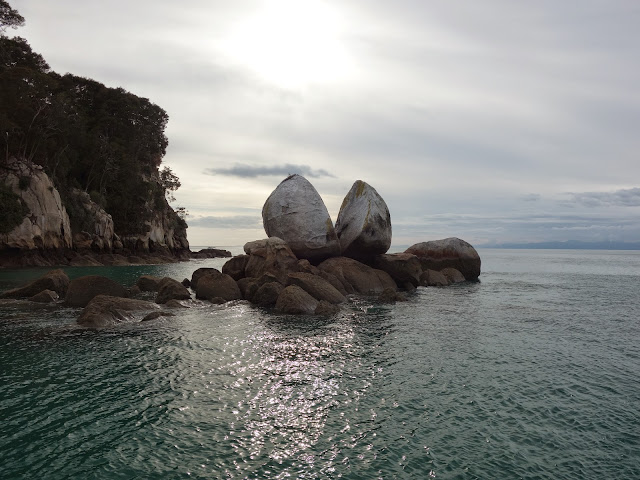
It wasn't long before reaching the the first scenic wonder, Split Apple Rock.

The taxi continued along the coastline, slowing as it passed an island where seals lazed on the rocky shore, and stopping in several bays to pick up or set down people heading to sea kayaking or tramping adventures. I got off at Awaroa and spent a couple of pleasant hours wandering along the beach and having lunch at the cafe of the lodge tucked away in secluded corner of the bay.
Trampers can take a shortcut across this inlet at low tide, but at high tide it's a much longer walk to go around it.

There are no jetties at any of the beaches. The water taxis have a long gangplank that unfolds to reach up the beach.

After lunch I returned to the beach and boarded the water taxi for the return cruise to Kaiteriteri and bus back to the holiday park. It had been and interesting and relaxing day.
Back in my cabin I checked the Lone Star Farms page for an update on the status of the Rainbow Road. According to the latest update, the road will not now be open until late in the week, presumably just in time for the Rainbow Rage race next Saturday. This is a problem for me as I was planning to cross early in the week. I would have to do quite a bit of backtracking to reach St Arnaud and I'm reluctant to do it and then discover that the road is not passable, and I can't sit around and wait then have to compete with the racers for accommodation (most is already booked out) at St Arnaud and at Hanmer Springs.
So I've reluctantly decided to abandon the crossing of the Rainbow Road and to continue around the top of the island instead. Finding the end of the Rainbow will have to wait for another time.

On the Great Taste Trail to Nelson...
Leaving Motueka this morning the weather was cloudy and cool. On the North Island, Cyclone Pam is battering the east coast.


The Great Taste Trail started about 7km out of Motueka, turning off the busy highway and heading for Mapua, where a short ferry ride took me across the inlet to Rabbit Island.

From the ferry, a series of forest roads and formed bike trails skirted the beachfront and crossed the tidal flats to Richmond.

The swing bridge was really quite strange to ride across. Near the middle it got a good sway going and made steering a straight line quite difficult.
From Richmond it was an easy cruise along the coastal bikepath into Nelson, where I was soon settled into nice room not far from the city centre.
Tomorrow I'm heading for Havelock, a centre for the green-lipped mussel industry. There are a couple of climbs along the way but the thought of a great big bowl of steamed mussels for dinner should be plenty of motivation.
Click here for a Doarama visualisation of the route.
Musseling up to Havelock...
Overnight the remnants of Cyclone Pam arrived and I woke to the sound of rain on the roof. I left Nelson in steady rain and took the cycleway out of the city as far as went, before joining the highway and enduring the cloud of spray raised by each truck that passed.
Fortuitously the rain stopped just as I reached the first climb of the day, the Gentle Annie, and I was able to strip of my rain jacket as the temperture began to rise. The Gentle Annie lived up to its name, and was followed soon after by the climb of the Whangamoa Saddle. Somehow this hill had escaped my attention but it proved a long and slow ascent
Eventually I topped the saddle and headed for the climb I did know about - the Rai Saddle, which proved a mere pimple after the Whangamoa.
On the descent from the Rai Saddle I came to a cafe and stopped for a coffee and cake, but did not linger long with 30kms still to go. I was not tempted by the cafes at Rai Valley or Pelorus Bridge, arriving at Havelock late in the afternoon.
Havelock is the self-proclaimed world capital of the greenshell mussel, and I was on a mission to get a potful of 'em for dinner.
I quickly settled into a room and after a lovely warm shower headed off to the Mussell Pot for the best dinner I've had this tour.


Riding the Sound
A few years ago I came to New Zealand for the first time, to walk the Queen Charlotte Track. My knees had given up after several arduous high altitude treks in Nepal, so to stop at a comfy hotel each night and have my baggage ferried between hotels was a nice change of pace.


Today I set out from Havelock for the short ride to Picton, and travelled along the Sound in the opposite direction, picking out the familiar bays and coves across the Sound as I went.
The air was quite cool as I set out, but there was a longish, steady ascent to warm me soon after leaving, with a nice view over Havelock at the top.

After a brief descent the road continued to wend its scenic way along the Sound.

Across the Sound is Anakiwa, at the end of the Queen Charlotte Walk.

And after some very sharp ups and downs I arrived at Picton, the port for the Cook Strait ferry services.

Getting off the bike on the Picton waterfront, I immediatelty felt a pain in my knee, and hastily took a room at the nearest backpacker lodge. I should have taken more care as it was a real dump, but at least I didn't have to walk (hobble) too far.
After a lazy afternoon watching ferries large and small come and go on the waterfront, I had a nice dinner and retired early to rest up the creaky knee.
Click here for a Doarama visualisation of the route.
A little Sauv Blanc in Blenheim...
This morning I couldn't get out of my dingy backpacker room quickly enough. Finding a nice cafe on the high street, I lingered over breakfast (mainly because they forgot my order), but with only a short flat ride ahead there was no need to hurry.

I was a little concerned to see if my knee was going to be an impediment on the bike, but it proved only a minor discomfort. There was a gentle climb out of Picton then it was pretty much downhill all the way to Blenheim, following the railroad through a deep valley which eventually opened out to more apple orchards and acres and acres of vineyards.
Blenheim is to white wines as Havelock is to green lipped mussels. When you see plantings like this, and the industrial scale wineries that process the harvest, it's no great surprise that there is a world glut of wines, and has been for several vintages now.

The picking has just started for this years vintage, and the backpacker lodges and cheaper accommodation is fully occupied by seasonal workers, so I had little choice but to book in to a motel. I'm going to take a lay day here to see if my knee (which seemed more painful after dismounting today) recovers before committing to the Molesworth road.
Click here for a Doarama visualisation of the route.
Boomed out of Marlborough country...
Blenheim was very cool this morning and for the first time I set out wearing arm and leg warmers and a gilet. I rode through kilometer after kilometer of vineyards, many with giant harvesters operating, and past more industrial scale wineries, accompanied by the boom of cannon fire - gas cannons to keep the birds away from the ripening crop. Even as I write this post I can hear gas cannons firing in the vineyards around me.


About 10 kilometers out of Blenheim the road began a long steady ascent to the Weld and Dashwood Passes, but the grade was moderate and the passes crossed comfortably enough with the help of a strengthening tail wind.
As I passed by the Awatere Valley turnoff (the Molesworth road) I felt a tinge of regret that I wouldn't be taking it, but my knee though improved is not up to any amount of walking, and I expect quite a bit will be needed. And soon after I met a fellow cycle tourist, a local from Nelson, who confirmed my thinking that the forecast rainy weather made the crossing inadvisable.
In between the green fertile valleys, an odd patch of pink. Huge evaporation pans for that gourmet salt that you pay so much for.

The wind continued to strengthen during the afternoon, and I was climbimg with little effort. The turbines are a giveaway that this is a windy place, but at least they were facing the right direction - towards me. And in the background my first glimpse of the Pacific Ocean.

After what seemed an easy 55 kilometers I found the turnoff to my stopover and pretty soon was settling into the bike packer hostel - a former shearers quarters now surrounded by vineyards.

Tomorrow I'll have a 75km run down to Kaikoura, and I'm hoping the wind will remain favourable, however a rain-bearing southerly change is expected in the late afternoon, so I must get to my destination before it arrives.
Click here for a Doarama visualisation of the route.
Subscribe to:
Comments (Atom)